British rule was beginning to lose its influence over India by the late 20th century. The 300 years long British Raj was reconsidering their stay on Indian soil. But, before turning their back on India, they partitioned the unified country into two separate nations – India and Pakistan. While the majority of the Indian people were against the separation, the Indian Muslims demanded the establishment of a separate region for the Muslims, free from Hindu influence. But, how did the Radcliffe line between India and Pakistan was mapped? Who formed the India Pakistan border in Kashmir? What was the meaning of sir Cyril Radcliffe partition of India and who was Sir Cyril Radcliffe?
The line that separates India from Pakistan was created on 12th August by Sir Radcliffe but was announced on 17th August 1947 to avoid further protests and killings. Here is the dark history of the Indian partition. Let us take a glimpse at how the lack of knowledge of one person decided the fate of India and its people for the generations to come! Also, read to know more about the Radcliffe Line between India and Pakistan.
Sir Cyril Radcliffe Partition Of India – The Unfortunate Event In The History Of India
If you study modern Indian history, one of the unfortunate events that you will come across during your learning is the unfortunate partitioning of India after the end of British rule. But, why do we call it an unfortunate event? Is it only because India was divided into two different countries? Or, is there something which is kept hidden from us? Read the article below till the last to find answers to the above questions.
The Maratha dynasty was declining. The Mughal Emperor was also shattering gradually. Such a grim situation proved perfect for the British East India Company to strengthen their base on Indian soil. Later, the Britishers extended their stay in our country for 300 years and became our colonial masters. After years of struggle and sacrifices by our freedom fighters, India became independent from British rule. But, at what cost?
While the Indian National Congress demanded the establishment of a free India, the head of the Muslim League, Muhammad Ali Jinnah had other plans for India. He protested for the establishment of a different nation for his Muslim brothers. While the INC was opposed to the views promoted by Jinnah, the British had no other option but to split India to avoid further conflicts and chaos.
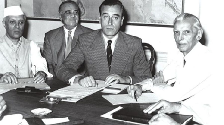
In the meantime, Jawaharlal Nehru of INC too supported the sir Cyril Radcliffe Partition of India as he wanted a more centralized state with homogeneity in the country. Thus, the partition of India marked its existence in the pages of history on 15th August 1947. While India was divided by the then Viceroy of India, Lord Mountbatten into India, East Pakistan and West Pakistan, another serious conflict unleashed itself. How in the world were the borders between India and Pakistan to be mapped? Who should be appointed for such a difficult task?
Also Read- Jawaharlal Nehru Speech On 15 August 1947 And Jawaharlal Nehru Speech
What Is The Radcliffe Line – The India Pakistan Border In Kashmir
By the time the British rulers decided to turn their back on India, the Political turmoil was sweeping the country in its full form. Mass protests, rapes, murders and killings were a common sight. India was internally divided into two sections, the Hindu majority group and the Muslim minority people. Others such as Punjabis and the Sindhis decided to support Hindus as the INC promised them full security.
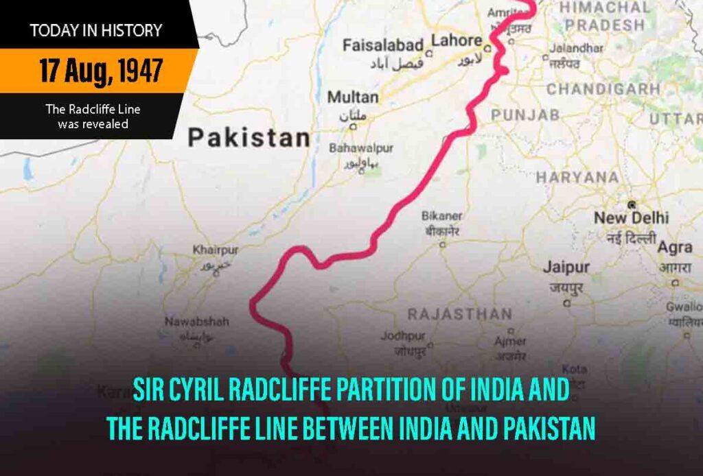
By the time India was declared Independent, the Radcliffe line between India and Pakistan was not yet announced. The India Pakistan border in Kashmir was already mapped and ready by 12th August 1047, but it was not announced publicly until 17th August 1947 to avoid further conflicts and chaos in the country.
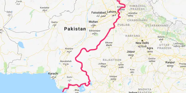
The Radcliffe line is the line that demarcates India from its neighbouring country Pakistan which came as an unfortunate outcome of the Indian partition. The Radcliffe line is between the Runn of Kutchh in Gujarat to the international border in Jammu, Jammu and Kashmir. The India Pakistan border in Kashmir – The Radcliffe Line was named after the chairman of the Border Commission – Sir Cyril Radcliffe.
Who Was Sir Cyril Radcliffe? The Man Who Changed The Course Of Indian History
While the task of mapping a line between India and Pakistan was coming closer, the British Government was in a hurry to finish off the task from its bucket list before leaving its colony. But, as days passed by, new problems emerged for the colonial rulers. While the mapping of the boundary between India and Pakistan was a daunting task to jump on, the added problem was who was to be appointed for the task. Moreover, the Britishers were looking for someone who could give an unbiased decision!

Finally, a ray of hope could be seen amidst darkness when Sir Cyril Radcliffe was appointed as the Head of the Border Commission to draw and map the final boundary between India and Pakistan. The Boundary Commission consisted of the head – Sir Cyril Radcliffe and two members from each – The Indian National Congress and the Muslim League. Sir Cyril Radcliffe and his team had only five weeks to finish his task. But, was he successful in his job? What was the outcome of such a separation?
Also Read- Pakistan Independence Day – Why Pakistan Celebrate Independence On 14 August
India Pakistan Border On Map – Radcliffe Line Between India And Pakistan
The territory to be divided consisted of 1.75,000 square miles, housing about 88 million people. For this, the Britishers appointed a lawyer, Sir Cyril Radcliffe, who had never visited India before. Additionally, he was not trained in cartography. When he arrived in India, he faced some added difficulties in mapping the border, the Radcliffe line between India and Pakistan. British India housed a majority of Hindus, but it also had in itself Muslim groups and Sikhs.
Added to the problem was the case with Bengal and Punjab. While there were Hindus in both regions, Muslims were also scattered here and there but they could not make a majority anywhere. Again, India also had princely states which were independent on their own. The Britishers could not divide them on the basis of religion. However, the lawyer was a responsible official and thus, irritated and helpless, he completed his task without any prior knowledge. He was also too adamant to ask for help from outside!
Thus, the border between India and Pakistan was drawn! Radcliffe gave away Lahore to Pakistan and kept Kolkata for Indian soil. In an interview, he admitted that he wanted to keep Lahore, the Capital of the then Punjab to India, but was compelled to associate it with Pakistan. Had he not done so, Pakistan would be left without any big city!
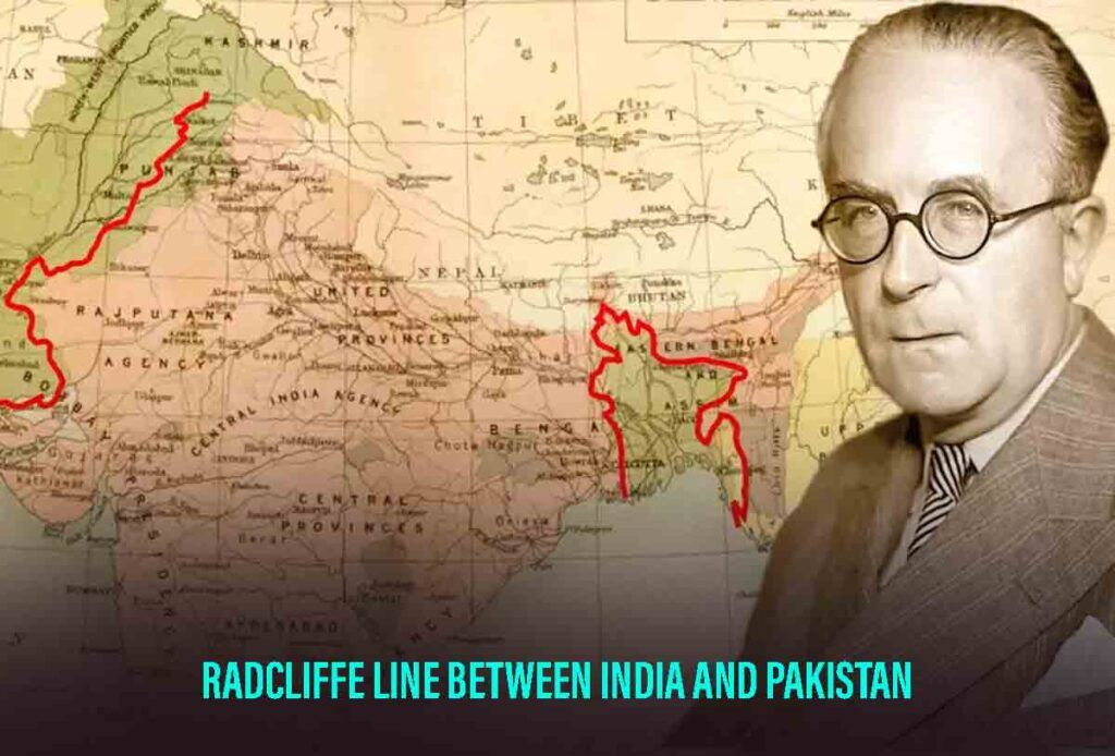
Again, instead of giving away Gurdaspur to Pakistan, Radcliffe kept it for India as Gurdaspur served as the link between India and Jammu and Kashmir. Again, instead of having a Muslim majority, the Murshidabad district of West Bengal was kept for India. Similarly, Khulna was given to Pakistan. Thus, it is clear that there was no basis for the mapping.
It was all done in a hurry and thus caused civic riots, rapes, murders and killings. Several people were positioned on the wrong side of the border. Confused people migrated in large numbers causing refuge killings and murders. Some parts of the border even ran between houses causing even further confusion and panic.
It is said that Sir Cyril Radcliffe was so saddened by what had happened, that he did not accept his money. He also left India the day after his job was finished and never visited the country again. Later, he told in an interview that the time was too short for a person to do such a long task. Had he been given two to three years, the outcome of the mapping might benefit everyone.
Also Read- Major Events Of Independence Day – Will India Celebrate 75 Or 76 Independence Day?
Facts About Radcliffe Line
- Sir Cyril Radcliffe had only one mother to draw and map the demarcation line between India and Pakistan.
- Sir Cyril Radcliffe, the chairman of the Head of the Border Commission was a lawyer by profession. He had no knowledge about cartography or related jobs.
- Apart from religious demographic to divide India and Pakistan, other factors such as natural boundaries, communications, watercourses and irrigation systems, we’re also considered.
- The weirdest fact about the Radcliffe line was that the Border passed through several houses! To be more precise, the situation was that different rooms of the same houses were placed in both countries.
- Later, Pakistan which includes East Pakistan and West Pakistan also separated and a new country called Bangladesh was established in 1971.
Conclusion
Whether the Radcliffe line was a boon or bane is still a debate. While it resulted in the formation of an entirely Muslim country, as demanded by Jinnah, it also did not quite provide justice to Pakistan. Radcliffe was somewhat biased towards Indian soil and thus kept important parts for India. Pakistan always received whatever was left after giving it away to India. This resulted in chaos, conflicts, and mass killings of people which was unexpected!
For more related articles, visit Discover
